
Walk a South Charleston Street
A reliable South Charleston street directory search moves from a modern address to a parcel, then from the parcel to records kept under names and deed references. Ownership is public evidence. Occupancy is a separate question. The county assessor may identify the person, trust, estate, company, or public body named as owner, but it does not list everyone inside a home. Keep each source in its proper role and record the date of every result.
- Enter the address in the Kanawha County Property Record Search. Save the parcel, current owner, situs and mailing addresses, legal description, and deed book/page.
- Open the West Virginia Property Viewer. Locate the same lot and inspect the parcels along that street segment.
- Take the deed reference to the Kanawha County Clerk Record Room. Read the grantor, grantee, date, and legal description.
- For one known person, use the official voter-status lookup. A whole-street list requires a lawful, specified request.
- For older households, consult Polk volumes, archive directories, newspapers, census records, and Sanborn maps. Test Charleston and South Charleston as place names.
The chain is address to parcel, parcel to owner, owner to deed, then date to historical evidence. That order prevents an old owner, tax-mail recipient, and current resident from being blended into one claim.
Search South Charleston Assessor Fields
The Kanawha assessor is the best first stop for a current South Charleston address. All displayed fields are optional, so a researcher can begin with a partial fact and tighten the query. Owner names use LAST NAME FIRST NAME without a comma. District and property type are menus, although every option and the exact partial-address matching behavior were not established in the official inspection.
| Field | Format | Street-directory use |
|---|---|---|
| Owner Name | Text | Find a known owner in last-name-first order |
| Parcel Address | Text | Start with a house number and street |
| Account Number | Text | Return to a known tax account |
| District | Dropdown | Narrow the county results |
| Map/Parcel | Multipart text | Match a known map reference |
| Legal Description | Text | Try lot, block, or subdivision words |
| Deed Book/Page | Multipart text | Bridge the parcel to a recorded deed |
A result may show the taxing district, street address, current owner, mailing address, legal description, deed book/page, sales and assessment history, land details, and links to a building record, map card, or tax data. Preserve the identifiers before following those links. No public coverage cutoff or image fee was posted.
The assessor search screen is the address entry point for the South Charleston street directory.
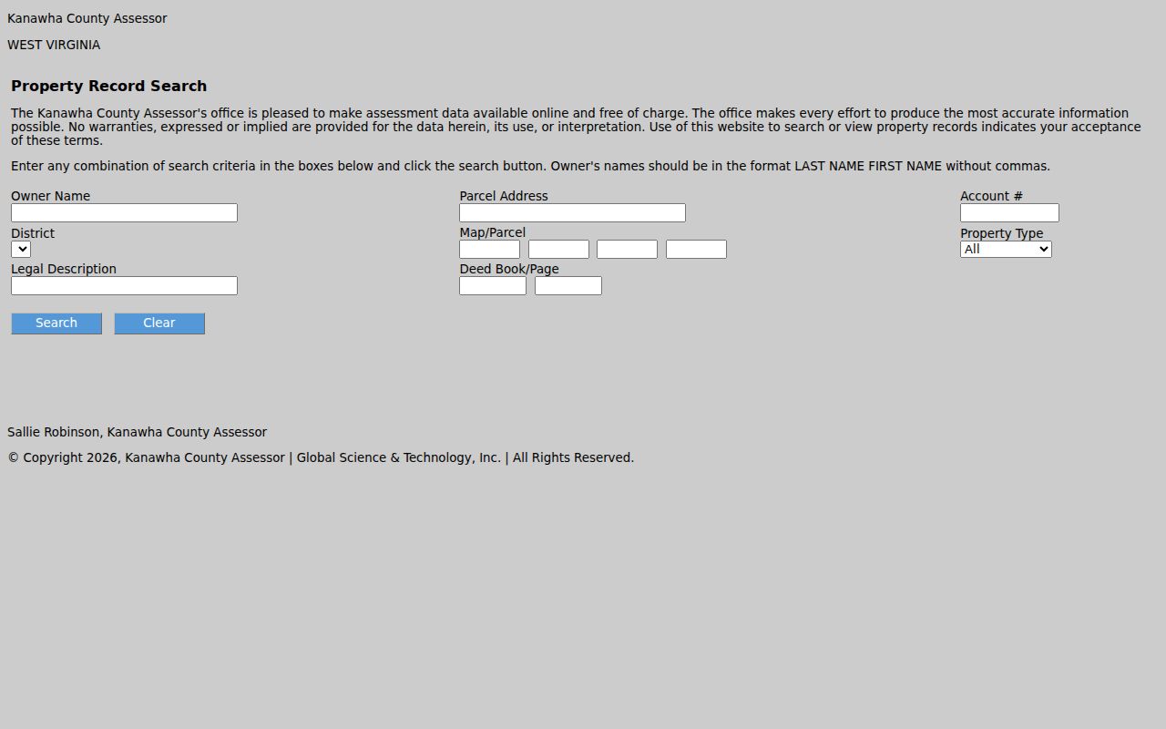
The captured form shows how one parcel can be reached by address, owner, map reference, legal description, or deed citation.
South Charleston Address Fields Differ
Three terms matter in a South Charleston street directory. The situs address is the physical location. The mailing address is where the tax notice goes. The legal description identifies the land in recorded terms. A post office box, an out-of-town mailing line, or a company address does not prove that the titled owner lives at the parcel.
- Situs address
- The street location of the assessed land or building.
- Mailing address
- The destination used for tax mail, which may differ from the property.
- Parcel
- A mapped unit of land with an assessor identifier.
- Legal description
- The land identity in deeds, often a lot, block, tract, or subdivision.
An inspected MapWV example named the City of South Charleston as the current owner, used a city post office box for mail, and described land in Jefferson Park. Its history also showed prior private owners and a Virginia Street address. Those are useful property clues, not a complete statement about who occupies the site.
Key distinction. An owner name is title evidence and a mailing address is contact evidence, not a full resident match.
Map South Charleston Street Parcels
MapWV turns one South Charleston address into a view of its street segment. Search an E-911 address, or select Kanawha County and choose parcel number, property owner, or property address. Partial owner text and incomplete street names are supported. Point, rectangle, and polygon tools can select an area, while a buffer expands a geometry search. Results stop at 1,000.
Zoom to about 1:18,056 before expecting parcel lines to become clickable. Turn on parcel, tax-district, and address layers. Hover to highlight a result, then click Basic Information. Save the GIS ID, owner, address, and parcel number. Flood and reference layers add context but do not identify residents.
| Exact location | Use E-911 Address; it does not accept post office boxes or rural routes. |
|---|---|
| Parcel search | Choose county, then parcel number, owner, or property address. |
| Area browse | Use point, rectangle, polygon, or buffer tools for nearby lots. |
| Save the map | Print accepts a title and note, while share and bookmark tools preserve context. |
The West Virginia Property Viewer capture shows the map used to follow South Charleston parcels by street.
The map supplies parcel context and a route to assessment detail. It is not a certified survey or a resident roll.
Note: If an empty search stalls the viewer, choose Start Over, select Kanawha County again, and rerun a narrower address.
South Charleston Records by Street
Current and historical South Charleston sources overlap without being interchangeable. The parcel number ties assessor and map data together. Deed book and page lead to the county record room. A street name can support a city permit request or an old directory check. Dates then guide census, newspaper, probate, and map research.
| Address record | Keeper | Evidence returned | Access route |
|---|---|---|---|
| Assessor parcel | Kanawha County Assessor | Owner, situs and mailing addresses, legal description, assessment, sale and deed clues | Free online search |
| Mapped parcel | WV Property Viewer | GIS ID, owner/address, layers, geometry, and assessment link | Free map, no login |
| Recorded deed | Kanawha County Clerk Record Room | Grantor, grantee, recording data, book/page, legal description | Office or request; no verified county web index |
| Voter record | WV SOS and Kanawha Clerk | Allowed status, residence, party, precinct, district, and registration fields | One-person lookup or restricted list request |
| Permit/code file | South Charleston Engineering | Released permit, inspection, zoning, or code evidence | Office or specific records request |
| Historical directory | KCPL and WV State Archives | Past name, address, spouse, and occupation clues when printed | Library or archive |
When the web route ends, use the fallback. The Record Room holds the deed path. City Engineering accepts a focused request. KCPL and the State Archives handle older directories and records. The street directory is strongest when these office, online, library, and archive channels are joined.
Trace South Charleston Street Deeds
No verified public online Kanawha grantor-grantee index was located. Begin with the assessor's book and page, then contact the Kanawha County Clerk Record Room at 409 Virginia Street East, Charleston, or call 304-357-0240. A grantor gives or sells an interest. A grantee receives it.
- Copy the current deed reference, owner, parcel, and legal description.
- Read the deed for grantor, grantee, date, type, book/page, and any plat.
- Search the seller as a grantee in an earlier record, matching the same legal description.
- If the parcel was split, follow the parent tract instead of forcing a modern street number into an old index.
- Compare changes with directory, census, obituary, probate, and permit dates before inferring occupancy.
The State Archives microfilm inventory lists Kanawha deeds from 1790 through 1910, a grantor index from 1790 through 1946, and a grantee index from 1795 through 1967. Later title work beyond those archive ranges belongs at the Record Room. This uneven access is why the South Charleston street directory needs both local and archive channels.
South Charleston Grid Meets Deeds
South Charleston's address history is tied to its planned form. After the Kanawha Land Company acquired about 1,800 acres in 1906, an orderly street grid was laid out. Modern addresses can connect to older lot, block, and subdivision wording. Jefferson Park descriptions in inspected parcel records show the method: when a street label fails, search the legal description and deed citation.
Charleston-titled directories may include nearby suburbs. Postal wording changed too. In 2014, USPS changed the preferred last line for ZIP 25303 from Charleston to South Charleston. Search both place names and street-suffix variants. No verified citywide street-renumbering or annexation year was found, so do not force every mismatch into one story.
The e-WV South Charleston history supplies the planned-grid context. The assessor and deed must supply proof for a given parcel. Postal wording, city limits, and recorded land identity can overlap without being equal.
South Charleston Voters and Permits
The West Virginia voter lookup checks one known person by first name, last name, and full date of birth. It cannot browse a whole street. State law permits access to selected voter fields, but withholds Social Security numbers, driver-license or nonoperator-ID numbers, phones, and email addresses.
A specified county or state list may be available on disk or paper at one cent per name, with approved selection and sort criteria. It carries bans on solicitation, advertising, and resale. Registration does not reveal ballot choice, full household membership, or certain current occupancy.
South Charleston Engineering, at 238 4th Avenue, handles permits, code, contractor validation, and zoning. No public address-search portal was verified. Request a stated address, date range, and exact file types. The West Virginia Freedom of Information Act supports reasonably specific requests, subject to exemptions.
Read South Charleston Streets Historically
The Polk volumes at KCPL cover Charleston and neighboring suburbs from 1908 to the present. They are on the Main Library third floor, are in-library only, and cannot be checked out or held. Where a street or reverse section exists, start with the address, then turn to the alphabetical entry. Exact reverse-directory titles and years were not verified.
The State Archives lists Charleston directory volumes from 1874-75 through 2016 with gaps. A Charleston title does not guarantee South Charleston coverage, so confirm each edition. The shelf, census pairing, and entry-reading methods appear in the South Charleston city directory.
WVU Sanborn maps add building context. The digital Charleston run includes sheets that explicitly include South Charleston, including a 1933 set. They can show footprint, material, use, and nearby features, but not an occupant. Use map evidence to frame the directory and deed trail.
Limits of South Charleston Street Records
A South Charleston street directory cannot promise a full household roll. Renters, guests, children, and other members may be absent from assessment records. Utility customer lists were not found as a public substitute. Federal law restricts motor-vehicle address data. The Address Confidentiality Program and covered-person redaction rules can hide or substitute a protected home address.
Records also go out of sync. A deed shows recorded ownership, not daily occupancy. A voter entry shows registration facts. A directory captures an editor's coverage at one time. A permit concerns work at a site. Compare dates, spelling, parcel identity, and keeper before deciding that two results concern the same person.
Lawful use. South Charleston address records support legitimate personal, family, property, and civic research. Never use them to stalk, harass, intimidate, or defeat a protected address.